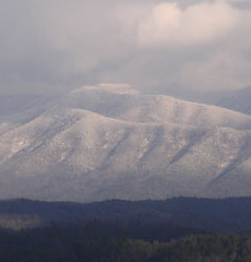
The name Chestnut Tops was chosen to signify the intent to replant the area with a blight resistant strain of the American Chestnut; the 1920 vintage stumps and hulks of the original American Chestnut dot the ridges of Chestnut Tops.
The original 156 acres of Chestnut Tops was acquired in 1990 and expanded to 170 acres by 2006. Historically, for at least ten centuries prior to 1828 this land was home to the Cherokee Nation. The Chestnut Tops area and surrounding mountains were called Shaconaqe, "place of blue smoke," Smokey Mountains.
Following a complicated and typically corrupt series of treaties between whites and the Cherokee, most Cherokee were removed to Oklahoma in February 1838 along the Trail of Tears; 14,000 began in Tennessee and fewer than 10,000 arrived in Oklahoma.
In 1837 Daniel Foute recieved a 5,000 acre land grant including Cades Cove and Chestnut Tops. Tracts containing Chestnut Tops were then acquired by Jourleman and later Headrick in the early 1960s to form Top of the World Community.
The covenants of Chestnut Tops state the intention to form a community of people sharing respect and appreciation for the environment, nature, history, and family.

For More Information, Contact:
G. Douglas Cox
P.O. Box 4506
Maryville, TN 37802
Voice:
865.982.9089 (home)
865-386-6392 (cell) |