Great Smoky Mountains National Park, encompassing some of the oldest mountains on earth, is located in the Appalachian mountains of North Carolina and Tennessee. The state boundary line bisects the park, which is one of the largest in the eastern United States. Measuring fifty-four miles long and nineteen miles across at its widest point the park consists of slightly more than half a million acres. Great Smoky Mountains National Park attracts the largest number of visitors annually of any national park, perhaps because it is located within a day's drive of over 60 percent of the nation's population. In recent years, more than nine million visitors have come to the park each year.
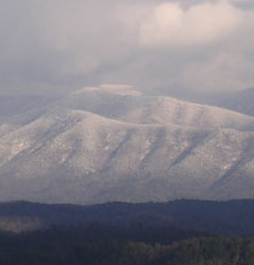
The park is named for the mist or blue haze that surrounds the mountains resulting from the interaction between the moist environment of streams and waterfalls and the thick vegetation. The Cherokee name for the area, Sha-co-na-qe, means "place of blue smoke." Rising upward through the blue "smoke" arc thirty-six miles of mountain peaks standing five thousand feet or more above sea level, sixteen of which exceed six thousand feet. The Cherokee Indians, the earliest settlers in these mountains, revered them as the sacred ancestral home of the entire Cherokee Nation, which at one time stretched from Georgia to the Ohio River.
The Cherokee arrived in the area around 1000 A.D. The Eastern Band lived in the Smoky Mountains where they farmed the land, raising a variety of crops which were supplemented by hunting and fishing.
Once the coastal settlers began moving westward beyond the mountains, there was increasing pressure to force the Native Americans to reservations west of the Mississippi. As a result, most Cherokees were forced to leave their home. Approximately one thousand of the Native Americans hid in the hills rather than be forcibly removed; today their descendants live on a fifty-six thousand acre area called the Qualla Boundary or Cherokee Indian Reservation that borders the national park and is shown on park maps.
For more information about Cades Cove please refer to the Great Smoky Mountain Association's publications.

For More Information, Contact:
G. Douglas Cox
P.O. Box 4506
Maryville, TN 37802
Voice:
865.982.9089 (home)
865-386-6392 (cell) |